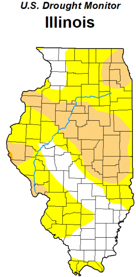
Most of Illinois Still in an Abnormally Dry Pattern
With everyone in Illinois agriculture looking at the sky for rain, Illinois State Climatologist Trent Ford says, “Forecasts for the next seven days show continued drier weather with only a few chances of rainfall, and near to above normal temperatures,” Ford said. “Without significant rain in the next week, conditions will likely worsen, and more drought impacts may occur.” Outside of a few areas of heavy rain, most places have had only 25 to 60% of normal precipitation in the past 30 days, and parts of northeast and western IL have had less than 25% of normal precipitation since the start of May. Chicago had its fourth driest May on record, and April and May total precipitation in Quincy was the third lowest on record.
The 7-day forecast from the National Weather Service shows some chances of rain across the state but with totals mostly less than a quarter of an inch. Temperatures are expected to remain in the upper 80s and low 90s this weekend and into next week before moderating a bit. The NOAA Climate Prediction Center also shows the highest chances of near to above normal precipitation between June 8 and 14, though outlooks for more than 7 days can be uncertain, Ford said. “It is likely the drought conditions will worsen before we see improvement if we do shift to wetter weather in June,” he said. The May 30th edition of Crop Progress and Conditions released by the IL Ag Statistics Service indicated: Topsoil moisture supply was rated 14% very short, 28% short, 54% adequate, and 4% surplus. Subsoil moisture supply was rated 6% very short, 31% short, 61% adequate, and 2% surplus.